 |
|
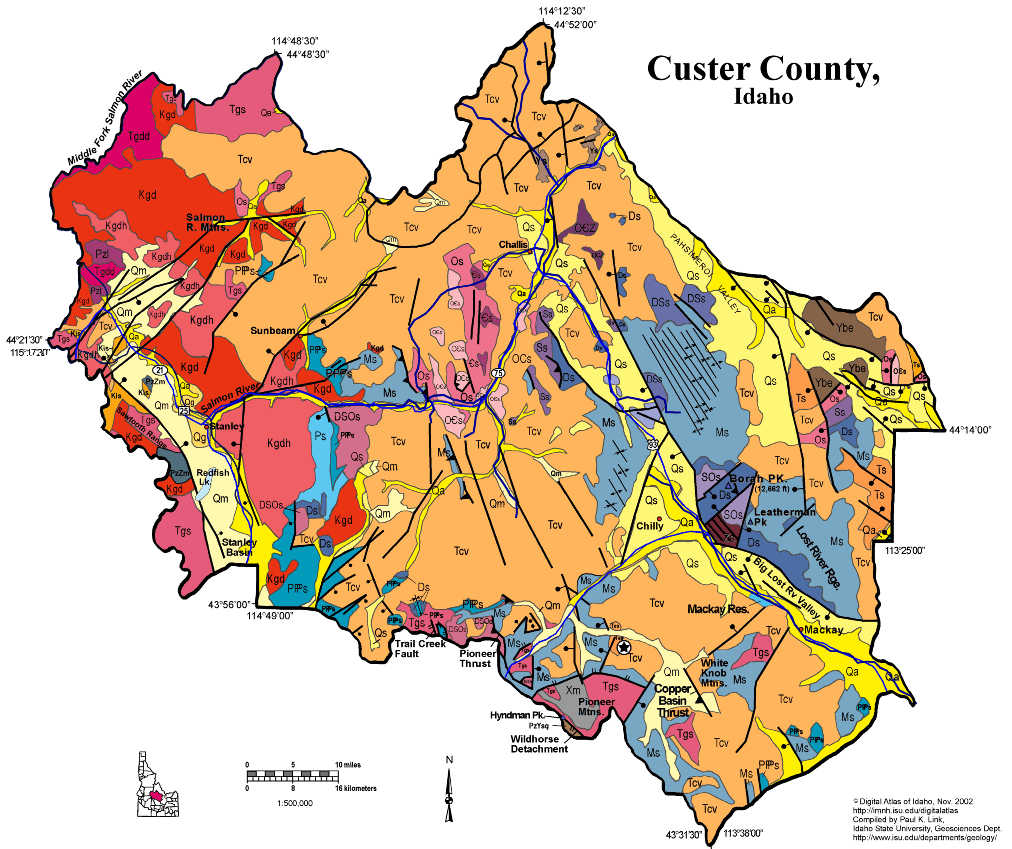
Click on the map above for a larger version
|
Geologic Units |
|
| Quaternary alluvial deposits | |
| Quaternary moraine and glaciofluvial outwash | |
| Quaternary surficial cover, fluveolian cover on Snake River Plain, alluvial fans (Snake River Group) | |
| Eocene Challis Volcanic Group, volcanics and volcaniclastics | |
| Eocene granite, pink granite, syenite, rhyolite dikes, and rhyolitic shallow intrusive | |
| Eocene granodiorite, granite, diorite, and shallow dacitic intrusive | |
| Cretaceous granite and granodiorite of the 2-mica suite (Idaho batholith) | |
| Cretaceous granite and granodiorite of the hornblende-biotite suite (includes megacrystic granodiorite and granite) | |
| Cretaceous syenitic rocks | |
| Lower Paleozoic sedimentary rocks (includes roof pendants near Stanley) | |
| Permian and Pennsylvanian sedimentary rocks | |
| Permian and Carboniferous sedimentary rocks (Snaky Canyon Formation) | |
| Mississippian sedimentary rocks | |
| Devonian sedimentary rocks | |
| Silurian sedimentary rocks | |
| Devonian and Silurian sedimentary rocks | |
| Devonian, Silurian, and Ordovician sedimentary rocks | |
| Silurian and Ordovician sedimentary rocks | |
| Ordovician sedimentary rocks | |
| Ordovician and Cambrian sedimentary rocks | |
| Neoproterozoic sedimentary rocks | |
| Belt Supergroup and related rocks (includes Meadow Creek metamorphic sequence) | |
| Paleozoic/Mesoproterozoic schist and quartzite | |
| Paleozoic/Paleoproterozoic metasedimentary rocks (includes metamorphic rocks on Mt. Harrison in Albion Range) | |
| Paleoproterozoic gneiss |
| Map Key | |
| Geologic units with unit designation. | |
| Normal Fault: certain; dashed where approximately located; dotted where concealed. | |
| Thrust Fault: certain; dashed where approximately located; dotted where concealed. | |
| Detachment Fault: certain; dashed where approximately located; dotted where concealed. | |
| Interstate Route. | |
| U.S. Route. | |
| State Route. | |
| Location of Rockwalk rock from the county. | |
| Cities. | |
| Feature location. |
Custer County
Custer County lies in the heart of Idaho, and contains as diverse geology as many states and some countries. The county is mainly rugged mountains, with flat habitable terrane only in the Lost River, Pahsimeroi, and Sawtooth Valleys.
The oldest rocks in the county are Paleoproterozoic gneiss in the core of the Pioneer Mountains core complex of the Pioneer Mountains above Copper Basin and Ketchum. Above this gneiss are Proterozoic and Paleozoic metasedimentary rocks, all intruded by an Eocene pluton. The core complex is uplifted on the Wildhorse detachment fault, which forms a domal pattern, and which moved from Eocene until Oligocene time.
In the Pioneer and Boulder mountains north and south of the core complex is the thrust belt of Paleozoic rocks. Ordovician, Silurian and Devonian deep marine strata are found in the hanging wall of the Pioneer thrust fault, faulted below Pennsylvanian and Permian Sun Valley Group. East of the Pioneer thrust is the thick Mississippian Copper Basin Group, which contains the black conglomerates found in the Copper Basin and East Fork Lost River areas.
The White Cloud Peaks, on strike to the northwest, contain similar strata to the Pioneers and Boulders. Here Cretaceous granodiorite, that underlies Castle Peak, highest in the White Clouds, intruded Devonian to Permian sedimentary rocks. Across the Salmon River at the Thompson Creek molybdenum mine, Cretaceous intrusions have produced mineralization still being mined in the 21st century.
This entire area, plus the Smoky Mountains west of Ketchum contain dark-colored organic-rich sedimentary rocks of the central Idaho Black Shale Mineral Belt, Mineral exploration and production in these rocks controlled the early economic development of the area.
The White Knob Mountains, west of Mackay, contain Mississippian limestone intruded by and Eocene granite. Extensive copper mineralization is found on the margins of the granite, and the Empire Mine and associated properties immediately west of Mackay are found in these rocks.
East of the huge Lost River Valley and in the footwall of the west-dipping Lost River fault, are folded Paleozoic limestones and quartzites of the Lost River Range. Borah Peak, highest in Idaho looms above Chilly and the ISU Geoscience Lost River Field Station at its base along the Big Lost River. The northern half of the Lost River Range, north of Willow Creek Summit is the Pahsimeroi Mountains, which contain folded Mississippian strata on the south and unusual breccia at Grouse Peak on the north end immediately east of Challis. East of the Lost River Range, in the northeast corner of the county are Eocene and Oligocene conglomerate and tuff in the Donkey Hills and a western corner of the Lemhi Range underlain by Mesoproterozoic Belt Supergroup.
The Pahsimeroi Valley extends north into the Salmon drainage, and lies on the hanging wall of the Lemhi fault.
The northern third of the county, north of the Salmon River, is underlain mainly by Eocene volcanic rocks of the Challis Volcanic Group, cut by northeast-striking faults of the trans-Challis fault system, which controlled location of vents and hydrothermal systems that controlled mineralization, mainly of gold in the Yankee Fork area.
On the western edge of the co0unty are the spectacular Sawtooth Mountains, looming west of Stanley Basin or Sawtooth Valley. These glaciated peaks are formed of both Cretaceous granodiorite of the Idaho batholith, and Eocene granite associated with the Challis Volcanic Group.
See geology and regional discussions in Rocks, Rails and Trails, plus the Link and Janecke article in Guidebook to the Geology of Eastern Idaho
P.K. Link, 10/02
Additional Reading
Rocks Rails and Trails: pages
Rocks of Central Idaho
Pictures -Idaho Mountains
Basin and Range Faulting
The Borah Peak Area & the October, 1983 Earthquake
Glaciation in the Mountains of South-Central Idaho
References on Idaho Geology
Section 3, History of Eastern Idaho
Section 3, Chapter 8 -"Famous Potatoes" Agriculture & Irrigation
Section 6, Chapter 20 - Root Hog, Big Butte & Craters of the Moon
Section 8, Chapter 24 -Ketchum, Sun Valley, and Shoshone
Click here to see a correlation of geologic units, and the associated time scale.
Click here for a printable version of this map.
|
Click on the button below to search the IdahoGeologic
Survey's index of Geologic Maps
|
 |