Geologic Units |
|
| Quaternary alluvial deposits | |
| Quaternary moraine and glaciofluvial outwash | |
| Gravels and terraces on western Snake River Plain | |
| Quaternary surficial cover, fluveolian cover on Snake River Plain, alluvial fans (Snake River Group) | |
| Pleistocene basalt lava | |
| Pleistocene and Pliocene stream and lake deposits | |
| Pleistocene and Pliocene gravels on western Snake River Plain | |
| Pleistocene and Pliocene basalt lava and associated tuff | |
| Miocene felsic volcanic rocks (Idavada volcanics), includes rocks designated as Tmf (Bond, 1968) in Owyhee County and Mt. Bennett Hills | |
| Tertiary sedimentary rocks, undifferentiated | |
| Miocene basalt (basalt of Weiser and basalt of Cuddy Mtn.) (split with Tpb is at 5 Ma) (includes rocks shown as Tpb (Bond, 1978) in Owyhee County and Mt. Bennett Hills | |
| Eocene granite, pink granite, syenite, rhyolite dikes, and rhyolitic shallow intrusive | |
| Eocene granodiorite, granite, diorite, and shallow dacitic intrusive | |
| Miocene felsic volcanic rocks (Idavada volcanics), includes rocks designated as Tmf (Bond, 1968) in Owyhee County and Mt. Bennett Hills | |
| Cretaceous granite and granodiorite of the 2-mica suite (Idaho batholith) | |
| Cretaceous tonalite and quartz diorite | |
| Paleozoic/Mesoproterozoic schist and quartzite |
| Map Key | |
| Geologic units with unit designation. | |
| Normal Fault: certain; dashed where approximately located; dotted where concealed. | |
| Thrust Fault: certain; dashed where approximately located; dotted where concealed. | |
| Detachment Fault: certain; dashed where approximately located; dotted where concealed. | |
| Interstate Route. | |
| U.S. Route. | |
| State Route. | |
| Location of Rockwalk rock from the county. | |
| Cities. | |
| Feature location. |
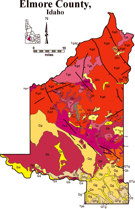
Elmore County
Elmore County covers a huge area from the Snake River on the south to the North Fork of the Boise River, deep in the Salmon River Mountains. It contains irrigated Snake River Plain farmland, vast areas of sagebrush desert, and much of the southern Salmon River Mountains, cut by three forks of the Boise River. Most of the population is near Glenns Ferry, on the historic crossing of the Snake Rive from the Oregon Trail. Mountain Home, on the bench above the Snake at the west end of the Mount Bennett Hills, is another population center.
The southern third of Elmore County is on the Snake River Plain. Basalt flows and lake beds (Glenns Ferry and Chalk Hills Formations) make up bluffs above the Snake River. The Lake Bonneville Flood came through this canyon 14,500 years ago and deposited fields of boulders, dubbed "Melon Gravel".
A normal fault bounds the northeast edge of the Snake River Plain, part of the eastern margin of the western Snake River Plain graben. This fault-bounded rift began to subside perhaps 12 million years ago on the shoulder of the Snake River Plain hotspot, then located west of Twin Falls.
East of the normal fault are the Salmon River Mountains, underlain by Cretaceous Idaho batholith granodiorites, and Eocene granite and granodiorite of the Challis magmatic complex. The area is cut by northwest striking faults parallel with Basin and Range trends. The forks of the Boise River, however, flow southwest, across this grain, and all occupy deep canyons. Mining towns in these canyons, like Atlanta, Featherville and Rocky Bar, struggle to exist into the 21st century. Placer mining spoils are evident in several places. Atlanta contains diverse silver and gold mineralization, associated with the Cretaceous Idaho batholith.
The west side of the Sawtooth Mountains, on the footwall of the Sawtooth normal fault to the east, form the northeastern edge of Elmore County.
See geology discussions of the Idaho batholith in Rocks, Rails and Trails.
P.K. Link, 10/02
Additional Reading
Rocks Rails and Trails: pages
Rocks of Central Idaho
Pictures -Idaho Mountains
Challis Volcanic Group & Intrusive Rocks
Lake Bonneville and its Flood
Disposal of Wastes at the Idaho National Engineering & Environmental Laboratory
References on Idaho Geology
Click here to see a correlation of geologic units, and the associated time scale.
Click here for a printable version of this map.
|
Click on the button below to search the IdahoGeologic
Survey's index of Geologic Maps
|
 |