 |
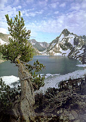
| Sawtooth Lake, Mount Regan. |
The portion of the Salmon River between North Fork and the headwaters is 173 miles long and drains approximately 6,000 square miles. Highways 93 and 75 border the entire stretch of river. The headwaters area, upstream from Thompson Creek, is within the Sawtooth National Recreation Area, which is administered by the USFS. Major tributaries include the Lemhi, Pahsimeroi, East Fork Salmon, and Yankee Fork Salmon rivers.
The drainage is characterized by mountainous terrain bisected by river valleys. Major mountain ranges include the Bitterroot Range along the Idaho/Montana border; the Lemhi Range, southwest of the Lemhi River; the Lost River Range, southwest of the Pahsimeroi River; the White Cloud Peaks, east of the upper Salmon River; and the Sawtooth Range within the Sawtooth Wilderness, west of the upper Salmon River. Numerous lakes with roaded access exist in the Stanley area. They include Stanley, Redfish, Little Redfish, Yellowbelly, Pettit, Alturas, and Perkins lakes.
The granitic watershed yields few nutrients to the upper Salmon River and the large moraine lakes. Sterile waters and a short growing season render the lakes and streams incapable of producing the fish necessary for a large consumptive harvest. Therefore, approximately 117,000 hatchery rainbow trout are stocked into waters in the upper Salmon River drainage. Early in the season the fishery is primarily supported by non-migrating hatchery steelhead smolts.
The reach of Salmon River from the East Fork to Yankee Fork contains good habitat for mainstem spawning chinook. Many of the Salmon River headwater tributaries are meandering meadow streams in a subalpine valley which are critical spawning and rearing areas for spring chinook.
Redfish Lake, and possibly Alturas, are the only Stanley Basin lakes that support sockeye production. Both Redfish and Alturas lakes support kokanee populations.