Page
11
|
Page
11
|
The routing of the Oregon Trail along the Bear and Snake Rivers was primarily controlled by earlier Native American and trapper's routes, combined with the fact that wagons could not negotiate rough lava fields. The Hudspeth Cutoff, on the other hand, was a direct and geographically arbitrary route located with little prior planning. Between Soda Springs and the Raft River Valley, it cut across six mountain ranges, far from reliable stream systems, and is today not followed by any hard-surface roads.
Later, when the Utah & Northern Railway was constructed, it followed the path of the Bear River north to Cache Valley, and then the Lake Bonneville Flood route north to Portneuf Narrows, the site of Pocatello Junction, and the Snake River Plain. From there the railroad followed the Snake River north to Eagle Rock (Idaho Falls), and then the basalt lava plain to Monida Pass and Montana.
The Oregon Short Line mainly followed the Oregon Trail from east to west across Idaho. Where the immigrants' wagons headed north at Soda Point to avoid the Gem Valley lava field, the rails headed directly across Gem Valley and down the lava-filled Portneuf River Canyon past Lava Hot Springs and Inkom to Portneuf Narrows. The railroad also cut directly west across the basalt lava plain from American Falls to Shoshone.Strange
Doings with Drainages in Southeastern Idaho
One of the fascinating
elements of the geography of southeast Idaho is the contortions of its streams
and drainage basins. In a few square miles of relatively flat valley bottom
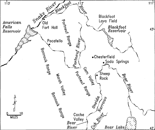
near Soda Springs are streams draining south into the Bear River, north to the
Blackfoot River, and west to the Portneuf River.
 |
|
Drainages
of Southeastern Idaho.
Click on image for a larger view. |
Pioneer geologist F.V. Hayden (1883, p. 409) described the lava fields and recognized the odd drainage patterns:
The region of the Blackfoot River ... is covered in all its lowest portions with flows of basalt which had their origin in craters that still show between the Blackfoot, Bear and Portneuf Rivers. The pouring out of basalt must have occurred extensively
The courses of the Bear, Portneuf, and Blackfoot Rivers seem contorted, and they are. Within the last million years, eruption of basaltic lava from the Blackfoot-Gem Valley lava field dammed the former northerly course of Bear River through northern Gem Valley and down the canyon of the present Portneuf. The Bear was forced to turn south at Sheep Rock (Soda Point), to flow into southern Gem Valley and the Lake Bonneville basin of Cache Valley. The drainage divide between the Blackfoot and Bear Rivers north of Soda Springs is a marsh formed above a basalt lava flow. There is no topographic barrier, but water drains downhill both to the north and south. The two hydrologic systems are connected in the subsurface, as demonstrated by the effects on ground water levels in the Bear River system near Soda Springs produced by the filling of the Blackfoot Reservoir in the mid-twentieth century.