|
Page
26
|
|
|||
|
|||
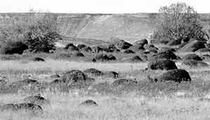
| Field filled with basalt boulders dropped by the Lake Bonneville flood, south of Hagerman, (Oct. 1995). These are the "petrified watermelons." | |||
Lake Bonneville and its Flood
Bonneville
Basin
The
Bonneville basin is a product of the Basin and Range faulting, which, starting
about 17 million years ago, uplifted the Sierra Nevada Mountains on the west
side of Nevada, the Wasatch Range in northeastern Utah, and the many ranges
in between. Water that falls on these ranges does not reach the ocean, but flows
to closed basins, of which the Bonneville basin is the easternmost.
The effect of climate change in the Lake Bonneville basin (the entire area that drains toward the modern Great Salt Lake, in western Utah, southernmost Idaho, and eastern Nevada) was to produce large lakes during the colder wetter glacial periods. During interglacial periods these lakes shrunk, and existed as saline water bodies like the present Great Salt Lake.
Calibration
of Dating Methods
Geologists
use several different methods to place ages on events related to Lake Bonneville
and the Pleistocene in general. Radiocarbon years are based on the broadly applied
method of dating organic material less than 30,000 years old with the naturally
occurring isotope of carbon. Other methods of dating have been calibrated to
tree rings and the growth rings of corals and are defined in "calibrated"
years, which yield ages generally 10 to 20% older than radiocarbon years (cerling
and others, 1994). Radiocarbon years are used in this book.
 |
 |
|
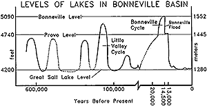
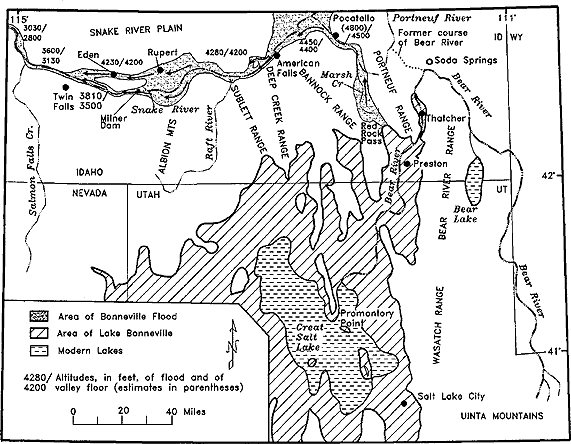
(left) Quaternary lake levels in the Bonneville basin, after Currey and others (1984) and McCoy (1987). (right) Map of Lake Bonneville and the path of its flood, after Malde (1968). Click on image for larger view. |
|