Page
27
|
Page
27
|
Steps
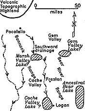
in the Development of Drainage in Southeast Idaho
Expanded from Mahoney
and others (1987).
|
A - Miocene (6 million years ago) |
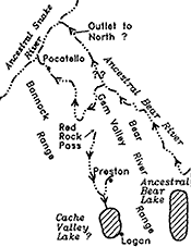 |
B
- Early Pleistocene (2 million years ago) The Ancestral Bear River probably drained northward through Gem Valley and across the Portneuf Range through what is now the Portneuf River Canyon. Alternatively, it may have drained northward across the northern end of the Portneuf Range. Drainage in Marsh Valley has reversed from southward to northward; superposed river canyons have been cut in eroding valleyfill. |
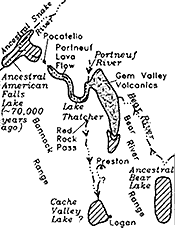 |
C
- Lake Thatcher and ancestral American Falls Lake, between 600,000 and about
50,000 radiocarbon years ago Pleistocene basaltic volcanism in Gem Valley formed a lava field which blocked the northward surface drainage of Bear River. About 600,000 years ago two basalt flows moved 50 miles down the Portneuf River Canyon to the site of Pocatello (Scott and others, 1982). Lake Thatcher formed in southern Gem Valley as northward drainage was blocked. Bear River may have drained southward into Lake Thatcher or may have lost much of its water to subsurface flow through porous basalt flows. The ancestral American Falls Lake formed about 70,000 years ago, dammed up by the Cedar Butte Basalt Flow just northeast of Massacre Rocks. |
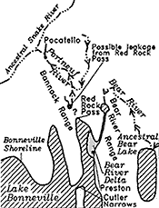 |
D
- Lake Bonneville (about 30,000 to 14,500 radiocarbon years ago) The southward cutting of Oneida Narrows, by Bear River, about 50,000 years ago, plus the wetter climate of the Pinedale glaciation, were instrumental in causing the rise of Lake Bonneville. The maximum lake level at 5090 feet may have been controlled by subsurface leakage through limestones at Red Rock Pass (D.E. Fortsch, Idaho State University, oral communication, 1993). The diagram shows the maximum extent of the lake northward into Gem Valley and the extent of the Bear River Delta (stippled). Ancestral American Falls Lake no longer existed (Hearst, 1990). |
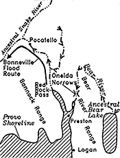 |
E
- Lake Bonneville Flood and Provo shoreline (14,500 radiocarbon years ago) The Bonneville Flood emptied northward after failure of the alluvial dam at the Zenda Threshold, just north of Red Rock Pass. In the American Falls area, the floodwaters spread out. Some of them flushed down the modern Snake River channel, but some went north and west down Lake Channel, to return to the Snake River near what is now Massacre Rocks. A lake stood at the Provo shoreline (the bedrock lip at Red Rock Pass) for about a thousand years until it began to rapidly recede about 13,000 years ago. |
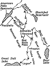 |
F
- Modern Drainage Patterns The Bear River flows first north and then south into the Great Salt Lake. The Portneuf River flows first south and then north through Portneuf Narrows to the Snake River Plain. The headwaters of the Blackfoot, Portneuf, and tributaries to the Bear are all located in flat marshy ground underlain by young basalt lava north and west of Soda Springs. |