Page
29
|
Page
29
|
The Lake
Bonneville Flood in the Pocatello Area
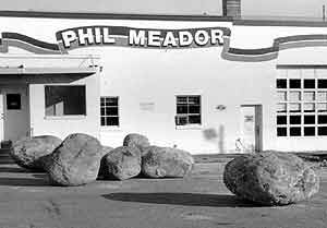
The flood removed the
Basalt of Portneuf Valley from the Portneuf Narrows area, where the water was
300 feet deep and moving at 60 miles per hour. As the water slowed down in the
Pocatello area it deposited boulders up to 12 feet in diameter in the downtown
Pocatello area. A flat delta deposit known as the Michaud Gravel was laid down
northwest of Pocatello, and is the present site of the city of Chubbuck and
the Pocatello airport.
 |
 |
|
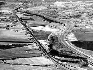
(left)
View of Portneuf River Valley and Pocatello, Idaho, looking northwest
from Portneuf Hill, south of Portneuf Narrows, (March, 1982). The Portneuf
River meanders in a valley widened by the Lake Bonneville Flood about
14,500 years ago. Some of the river's meandering has been curtailed by
construction of the Union Pacific Railroad. In the upper left, just west
of the railroad tracks, the Portneuf enters a flood control channel built
by the U.S. Army Corps of Engineers after much of downtown Pocatello was
flooded in February, 1962 and 1963. (right) Basalt boulders up to 8 feet in diameter on North Main Street, downtown Pocatello, (April, 1990). |
|