Pictures
- Southeastern Idaho
|
|
|
|
|
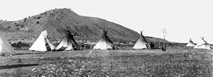
Teepees camped in the Pocatello Valley, 1895. View looks north to the west
side of the valley near Grant Street at the Riverside Golf Course. Photo
used courtesy of the Idaho Museum of Natural History and the Smithsonian
Institution. |
| |
|
|
(above
right) The reduction in size of the Fort Hall Indian Reservation and early
rail routes, 1868-1902. The Bannock and Shoshone were relocated to the Fort
Hall Indian Reservation beginning in 1869. The original reservation was
larger than modern day Bannock County and extended south to Red Rock Pass
and east nearly to Bancroft. The growth of American civilization, especially
the building of the railroads, caused two reductions of the reservation,
in 1889 and 1902. Redrawn from Union Pacific Railroad map. Click
on image for larger view. |
|
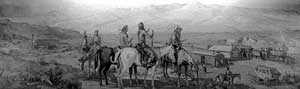
Painting in the Union Pacific Depot in Pocatello, painted by Bethel M. Farley
in 1943, (picture taken in April, 1996). The view looks south toward Kinport
Peak and the Bannock Range in 1878, with the narrow gauge railroad train
headed north to Eagle Rock, Monida Pass, and the Montana mines. Chief Pocatello
and his band survey the scene on the left, with Mink Creek and Scout Mountain
behind them in the distance. The narrow gauge depot was probably a boxcar
located, as shown, near the intersection of Jefferson Ave. and Alameda Road.
The view is fictionalized as there was never a depot of this size.
|