Page
53
|
Page
53
|
The
Coming of the Railroads
By the middle of
the 19th Century, the immense value of railroads to the American economy had
become apparent. They were the only reliable means of transportation; they could
operate in all kinds of weather and their ability to haul heavy loads permitted
unparalleled growth of industry and the economy.
|
Across the sagebrush desert of the Snake River Plain west of American Falls, there were no towns. The sidings were named by the railroad planners. E.P. Vining, former general freight agent of the Union Pacific system, described how the names (Wapi, Minidoka, Kimama, Owinza, Ticeska, etc.) were derived.
|
The need for rail transportation in the newly settled western areas was manifest, but until secession, neither Northern nor Southern politicians could agree to any route which did not originate in their territory. Almost at once after secession and the departure of Southern politicians, Congress adopted the Pacific Railroad Act of 1862 which provided for a transcontinental line linking the east with California roughly along the 43rd Parallel (that is through the newly created Idaho Territory).
Actual construction of the transcontinental rail line had to wait until financing became available after the Civil War. The first rails of Union Pacific Railway Company were not laid until 1865. After that, construction moved ahead with great speed. The Union Pacific Railway was building westward from Omaha, Nebraska, and the Central Pacific Railway was building eastward from Sacramento, California. Neither railroad passed through Idaho. The junction took place on May 10, 1869, at Promontory Point, in Utah just west of Brigham City at the north end of the Great Salt Lake. This was the cause for celebrations throughout the United States. For the first time, the east and west coasts were linked by a rapid, dependable form of transportation which permitted unlimited growth.
Residents of the new Territory of Idaho, established just 6 years earlier, were confident that after the junction of the transcontinental railroads, it would be only a short time until Idaho would be connected to the transcontinental line. They were shocked when Union Pacific management announced the company was financially incapable of building a line into Idaho. The area did not have enough commerce to justify the large expenses of construction.
The
Utah & Northern Railroad Company
Union Pacific also
refused to construct a connection between Ogden and the Territory of Utah capital
in Salt Lake City, just 32 miles away.
|
Brigham Young, President of the Mormon Church and governor of the Territory, is alleged to have said something along the lines of:
|
In order to connect Ogden and Salt Lake City, to bring rail service to other areas of the Mormon Empire, and especially to connect Utah with the new mines in Montana Territory, the Mormon Church established several rail companies to construct and operate a rail network. The broad gauge Utah-Central connected Ogden with Salt Lake City.
To reach the Montana mines, a narrow gauge road called the Utah-Northern Railroad Company was established in 1871. From Ogden the road was planned to extend through Brigham City and Logan to the Bear River, then up the Bear to Soda Springs where church leaders owned property, and then through the mountains to the Snake River and on to Montana. While the area to be traversed was known to be rugged, it avoided the Fort Hall Indian Reservation. The proposed route was chosen over a water level route along Marsh Valley to the Snake River Plain, that had been recommended by surveyors.
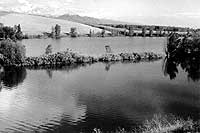 |
| Line of trees growing on roadbed of planned Utah-Northern Railroad at Johnson Reservoir north of Preston. The route was rejected after the reorganization of the Utah & Northern Railway in favor of a route across the Bear River and up Battle Creek, (May, 1992). " |
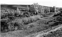 |
| Similar view to previous photo at Johnson Reservoir, but taken in October, 1992, when the reservoir was empty. |
The Utah-Northern Railroad was incorporated on August 21, 1871, and construction began at once. The road did not hire a railroad construction company to do the work but relied on the usual Mormon Church method of constructing public improvements: volunteer labor, utilizing their own equipment, would do the necessary construction in a cooperative, communal manner. Progress was painfully slow. By May 2, 1874, the line extended only 74 miles to Franklin, Idaho Territory, just across the Utah-Idaho border. Construction halted at this point. Lack of constant, remunerative sources of income, a grasshopper infestation in the neighboring farm lands and the economic Panic of 1873 combined to dry up funds for construction. The line was gradually extended to the north, through what is now Preston and to the south side of the Bear River near Battle Creek, before full receivership took place; but construction by the Mormon Church essentially ended.
The narrow gauge road was purchased by interests associated with Union Pacific at a receiver's sale in 1878 and construction began again. Although the roadbed had been constructed for 14 miles north of Preston to Riverdale, the route up Bear River via Oneida Narrows was abandoned as being impractical. The grade was too steep and the mountainous terrain was too cold and would be difficult to operate in winter. Instead, the route suggested earlier by surveyors through Red Rock Pass north of the Bear River crossing and down Marsh Creek to the Snake River Plain and then north to Montana was adopted. It would be cheaper to build, having no grades of consequence, except where the road came up Battle Creek out of the Bear River valley north of Preston, and would permit faster service. The water level route had one king-sized flaw: it ran directly through the Indian Reservation from Red Rock Pass to the Blackfoot River, a distance of 75 miles.