|
|
|
Snake
River Plain Aquifer
|
|
|
Source
|
Annual
Recharge
|
Annual
Outflow
|
|
Irrigation diversions |
5.1
|
|
|
Valley underflow |
1.5
|
|
Precipitation |
0.8
|
|
River seepage |
1.3
|
|
Total
|
8.7
|
|
Pumping for irrigation |
|
1.6
|
|
Springs & river gains |
7.1
|
|
Total in millions of acre-feet
|
8.7
|
| Estimated
annual water budget for the Snake River Plain Aquifer (from Hackett and
others, 1986). Numbers are in millions of acre-feet, that is enough water
to cover a million acres one foot deep. |
Snake
River Plain Aquifer
The Snake River
Plain Aquifer underlies about 10,000 square miles of eastern Idaho. Its annual
recharge and discharge is estimated at 8 million acre-feet, and its storage
capacity is estimated at 200 million acre-feet, enough to cover the entire state
of Idaho with 4 feet of water. The aquifer is recharged by precipitation that
falls on the ranges to the north and south and flows into rivers whose discharge
is absorbed into porous sediment. Recharge by irrigation water is another important
source for the aquifer.
More than 3 million acres
of land on the Snake River Plain were irrigated in 1980, of which 1 million
were supplied by ground water and 2 million by surface water from canals (Whitehead,
1986).
The
Growth of Agricultural Idaho
In the
1870s, economic growth in southern Idaho awaited several things. A reliable
and adequate transportation system, needed to carry produce to market and to
bring back machinery and equipment and the people to operate them, arrived in
the early 1880s with the railroads. The territory grew and became a state; the
state grew and towns began to proliferate along the rail lines. Vast areas of
southern Idaho lay unused and unoccupied, however, because of a lack of water.
Irrigation projects were needed.
|
|
|
|
|
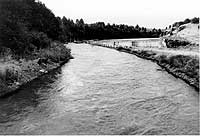
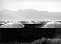
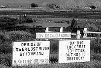
(left) Last Chance
Canal at its headgate along the Bear River northeast of Grace, (august,
1991).
(center) Sprinkler
irrigation against the summer sun, Star Valley, Wyoming, (June, 1977).
(right) Sign protesting
Idaho Department of Water Resources policies in the lower Big Lost River
drainage, (June, 1995). During drought years in 1993 and 1994 the water
table dropped in this area because there was not enough recharge to keep
up with irrigation withdrawal of both surface and ground water. Hundreds
of cottonwood trees along newly dry watercourses died.
|
Early
Irrigation Failures
Although visionary
engineers like Arthur Foote, who surveyed and attempted to start canal systems
in the Boise Valley in the 1880s, saw the potential in irrigated agriculture
in Idaho, large irrigation systems on the Snake River Plain were stymied by
lack of investor capital through the 1890s. Although the Mormon Pioneers had
made the desert bloom in their corner of the state, central and western Idaho
remained the territory of cattle and sheep grazers who neither needed irrigation
nor welcomed the fences and restrictions which came with building of farms.
The Carey Act, named
after a Wyoming senator, was passed by Congress in 1894 to stimulate state and
private cooperation to develop canal systems. The Act gave western states up
to a million acres of Federal land if the land could be irrigated or reclaimed.
Idaho contains 3/5 of all land reclaimed under the Carey Act.
Arthur
DeWint Foote was a mining engineer who saw the great potential for irrigation
in the Boise Valley as early as 1881. His visionary schemes, backed by determination
and hard work, but not by outside investment, all came to naught. His story
is painted in his wife's memoirs (Foote, 1972; Paul, 1975), and documented
in historical fiction in the exquisite book "Angle of Repose"
by Wallace Stegner.
"He was not
foolish or mistaken. He was premature. His clock was set on Pioneer
time. He met trains that had not yet arrived, he waited on platforms
that hadn't yet been built, beside tracks that might never be laid.
Like many another Western Pioneer, he had heard the clock of history
strike, and counted the strokes wrong. Hope was always out ahead of
fact, possibility obscured the outlines of reality." (Stegner,
1971, p. 382).
|
top