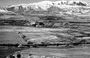
| Early
summer scene of the Bear River and the Southern Bannock Range, Cache Valley,
Idaho, taken looking west from the northwest of Preston. Weston Mountain
is the high ridge in right background. The lower ridge, cut by two steep
canyons, is composed of the Late Proterozoic Pocatello Formation. The West
Cache normal fault runs north-south near the base of the mountains. This
part of Cache Valley is mantled with several hundred feet of fine sands
and silts deposited in lakes, the latest of which was Lake Bonneville. The
Bonneville shoreline (5,090 feet) is a short way up the slope of the mountain.
The Provo shoreline (4,740 feet) is the prominent horizontal line at the
base of the mountains. The conspicuous terraces between the Provo shoreline
and the present Bear River level (4,450 feet) were formed as Bear River
incised the lacustrine sands and silts as the level of Great Salt Lake fell,
(June 1984). |