Page
101
|
Page
101
|
Hudspeth
Cutoff
West
from Marsh Valley the Hudspeth Cutoff crossed the Bannock Range, Blue Spring
Hills, Deep Creek Range, and Sublett Range before reaching the Raft River Valley
and joining with the California Trail near present-day Malta. Twin Springs,
between present-day Rockland and Holbrook was one of the few reliable water
supplies.
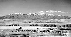 |
| Malad Valley and Samaria Mountain, looking west from Interstate 15, south of Malad City, (November, 1984). |
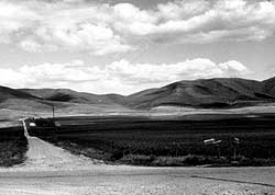 |
| Jensen Pass over the Deep Creek Range from southern Arbon Valley, (June, 1990). This is where the Hudspeth Cutoff crossed into the Holbrook area. Lorenzo Sawyer wrote about the country along the Hudspeth Cutoff thusly: "The mountains in this region seem piled up in the most wild and romantic confusion." |
Pioneers chose the Hudspeth Cutoff in the great rush of 1849, when, sheeplike, they sought a more direct route to California. It is estimated that from June 20 to August 31, 1849, 250 wagons a day (an estimated16,000 to 25,000 people) traveled this route, even though it was unproven, more difficult, and as it turned out, did not save any time. The Pioneers were desperate to get to California first. About 45,000 traveled it in 1850 and 50,000 in 1852. The cutoff had a life of perhaps 10 years since few went that way after 1859, as the California gold fields played out. Arthur Hope's book "The Hudspeth Cutoff, Idaho's Legacy of Wheels" is a detailed account of the route.
Empty
Country
The vast
area from Malad City west to the Raft River Valley is mainly empty. There are
few paved roads, and no gas stations. This is dry, sparsely settled country.
Although much of it was homesteaded near the turn of the century, most of the
farm houses were abandoned in the 1930s and the land is now divided into thousand-acre
dry farms. The mountains are not high enough to catch significant winter snows
and the streams in the valleys are small and unreliable. Extensive irrigation
systems are not feasible. However, if most of these hardy farmers, who remain
here, were given the choice, they would live nowhere else.
Geology
of the Malad Area
The Wasatch
fault runs along the east side of Malad Valley, and there are several active
faults in the area to the south and west. Malad Valley is thus a half-graben,
with the sedimentary valley fill generally tilted east.
The Bannock, Deep Creek, and Sublett Ranges as well as the Samaria and North Hansel Mountains are underlain by Paleozoic rocks, mainly limestones. These mountains are generally good fossil hunting country, with horn corals, brachiopods and gastropods easy to find if one knows the right place and is prepared to walk. There are several areas of limestone caverns. Air escaping from these caves on northern Samaria Mountain sometimes causes the mountain to "moan" in early spring.
Lake Bonneville extended north into the southern parts of Malad, Curlew and Juniper Valleys. Its shorelines can be seen if one looks closely, usually near the top of the level of plowed fields. They are generally more prominent in the southern parts of the valleys, closer to the Utah border.
Settlement
and Brigham Young's Placement of the Utah Border
The first
colonization of the Malad Valley, by Mormon cattlemen, was in the early 1850s.
The settlers were recalled to Salt Lake City with the coming of the federal
army of occupation (Johnston's army) to Utah in 1857-58. The first permanent
settlement was in 1863. Malad City was settled mainly by Mormon converts from
Wales.
Brigham Young came through the Malad Valley in 1855. Acting on the basis of astronomical observations by Orson Pratt, he marked the boundary line between Oregon and Utah territories as 108 miles from Salt Lake City, near the present town of Woodruff, Idaho. Although this placement was very close to correct, many Mormon settlers in Malad, Cache, and Bear Lake Valleys claimed that they were actually in Utah. The matter was not settled until the U.S. Government survey of 1872.
Early
Malad City and Oneida County
Malad
City grew up as a composite community in which Mormons, Gentiles, and Mormon
apostates (the Josephites) dwelt without much friction. Soda Springs was the
first county seat of Oneida County, which in the early 1860s included all of
southeastern Idaho. Transportation from the Malad Valley to Soda Springs was
difficult and the county seat was moved to Malad City in 1866. This move quieted
hostilities between Malad Valley Mormons, who thought (or hoped) they were actually
in Utah, and Gentiles. Oxford (in Cache Valley), served as the Federal Land
Office until 1885, and many Oneida County officials lived there.