|
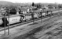
| Montpelier railway station, (March, 1992). |
|
|
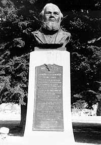
| Historical marker and statue at the Paris Tabernacle. Text reads "Charles Coulson Rich, 1809-1883. Pioneer builder of the west. Major-general of the Nauvoo Legion. Alderman of the city of Nauvoo in the time of Joseph Smith. Pioneer of Utah, 1847. Chairman of the first committee to organize civil government in the Rocky Mountains. Colonizer of San Bernardino Valley, California in 1851. First mayor of San Bernardino city. Member of the Utah territorial legislature for many years. Colonizer of Bear Lake Valley, 1863, where he lived and died. Husband of six wives and father of fifty children. Friend of the Indians, humanitarian. Apostle of the Church of Jesus Christ of Latter-Day-Saints, thirty four years. One of God's noblemen." This monument erected by the citizens of Bear Lake Valley, the Utah Pioneer trails and landmarks association and his descendants, (May, 1991). |
|
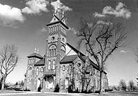
| Paris Tabernacle, designed by John Young (son of Brigham) and built between 1884 and 1889, (March, 1992). |
Montpelier
Montpelier (elevation
5,920) was founded in 1864 as a Mormon farming community, comfortable with its
remoteness. The west-building Oregon Short Line reached the community in 1882,
and for a while there were two Montpeliers, one the established Mormon community,
the other the largely Gentile railroad outsiders, regarding each other with
suspicion. The railroad built a repair shop and a roundhouse and the town served
until recently as a railroad division point. Farnworth (1993) relates stories
of Montpelier and the Oregon Short Line. At the time of statehood in 1890 Montpelier
was the 9th largest city in Idaho.
The population of railroad workers was separate from the Mormon settlers of Bear Lake County, who farmed the western and southern ends of the lake and established the county seat at Paris. In the late 1800s and early 1900s, the road from Paris to Montpelier was often impassable due to washouts and mud. In 1911, the railroad company built a branch line to Paris to serve the farming area but motor vehicles and World War II brought its demise in 1943. World War II also brought a large airfield out on the flat marshy country north of Bear Lake, but it is almost totally unused now.
Geology
Bear Lake Valley
is topographically high, (near 6,000 feet) and has long cold winters and short
summers. The valley is a fault-bounded basin, or graben, with normal faults
on both the east and west sides. The largest fault borders the east side of
Bear Lake, and has been dropping the valley downward and tilting it eastward
with respect to the Bear Lake plateau for perhaps 10 million years. Total displacement
on this fault is close to 10,000 feet.
The mountains of the Preuss and Aspen Ranges to the northeast of the Bear Lake Valley belong to the Meade thrust plate of the Idaho-Wyoming thrust belt. This is the area that contains the rich phosphate deposits of the Permian Phosphoria Formation, deposited in a nutrient-rich warm sea about 250 million years ago. Mining of the Phosphoria Formation has been and will be a major influence on the economy of not only the Bear Lake area, but much of southeast Idaho.
The Bear River Range on the west of the Bear Lake Valley contains Lower Paleozoic and Late Proterozoic rocks of the Paris thrust plate. The Paris thrust extends along the east side of the Bear River Range and places these older rocks over younger Paleozoic rocks of the Meade thrust plate.
Phosphate
Mining History
Underground
phosphate mining began in Georgetown Canyon in the early 1900s and a phosphate
processing plant was built in 1957. Open pit mining began in 1958. An avalanche
destroyed many of the facilities and the processing operations were moved to
Conda, north of Soda Springs, in 1964.
The oldest phosphate mine in Idaho is the Waterloo Mine in Montpelier Canyon, about 3 miles east of the city of Montpelier. Mining began in 1907 and the mine was closed in 1929. The property was reopened from 1945 to 1958.
Underground mining of phosphate began in the Slight Canyon area north of Paris in 1920.