Page
117
|
Page
117
|
|
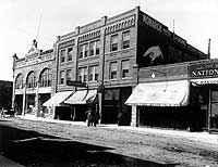
| View of the north side of the 200 block of West Center Street, about 1914. The Hub Building on the corner is now (1993) occupied by The Paris women's clothing store. The building on the extreme right is the Bannock National Bank, now occupied by the First National Bar. Note the sign on the front of the Monarch Hotel building in the center of the block. Bannock County Historical Society Collection. |
Southwest
is West; Southeast is South
The railroad
line ran through Pocatello townsite in a south-easterly to north-westerly direction
and when the streets of Pocatello were laid out, they followed the railroad
configuration, resulting in some confusion throughout the years. We follow custom
in this book, referring to the northwest-southeast streets as running North-South,
and the northeast-southwest streets as running East-West.
The
Legacy of No Urban Planning
In his reminiscences
of life in territorial Idaho just before statehood, Oscar Sonnenkalb, a surveyor
and civil engineer, commented on the layout of Pocatello with vitriolic language.
The practice of building on either side of the railroad established, in effect,
two competing villages, laid out without regard to drainage, natural barriers
or the desirability of providing streets where buildings would have the "desirable
equal chance for morning and afternoon sunlight."
Visitors often comment on the narrow streets of Pocatello, but both Pocatello and Idaho Falls were laid out with them. That was the norm in city planning at that time. The lack of park land along the river banks has remained a blight on the ambiance of downtown Pocatello.
|
Pocatello Townsite, Sonnenkalb charged, was laid out with little foresight because the plans were not worked out by practical civil engineers but by clerks in the Land Office,
|
 |
 |
|
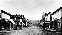
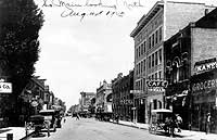
(left) View looking west on West Center, about 1890. The Hub Building is on the right hand side. The next cross street is Main (then Cleveland Avenue). The Pioneer Building is southeast of the intersection of West Center and Main. Bannock County Historical Society Collection. (right) View of the 100 block of South Main Street looking north, August 1913. Both horse-drawn and internal combustion vehicles are on the street. The Nicolet (Whitman) Hotel occupies the tall light-colored building. The Palm Cafe (originally the Wrensted Building) to the right of the hotel was destroyed by a windstorm in June, 1992. The site was rebuilt in 1993 as the Continental Bistro. The Pioneer Building is on the southeast corner of Center and Main. In 1996 the downtown U.S. Post Office branch was relocated there. The Petersen Furniture building can be seen in the distance on the east side of Main. This street was, until 1906, called Cleveland Ave., but the name was changed because of retrospective political animosity toward the Democrat, the only man to be twice President. Bannock County Historical Society Collection. |
|