Page126
|
Page126
|
Establishment
of a Public Water System
The city took James
Murray and company to court over rates and finally, in 1914, won ownership of
the water company. A water bond was passed August 26, 1914. However, appeals
of the decision to the Idaho Supreme Court and intransigence by Murray delayed
city possession until 1916. Water meters were installed shortly thereafter.
Water
Meters and Annexation of Alameda
Some
progress comes slowly in Idaho. In 1996, much of what had been the town of Alameda
still did not have water meters in private houses, pursuant to an agreement
made when Alameda was consolidated with Pocatello in 1962. The mayor of Alameda
at the time was George Hansen, later long-time congressman and convicted felon.
The annexation made Pocatello, for a short time, Idaho's largest city. Boise
immediately annexed ground on its perimeter and regained first place.
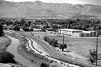
Although many in
Idaho and even some in Pocatello, do not know this, the Portneuf River
area contains a great diversity of natural settings where birds and wildlife
may be seen through all twelve months. Glenn Ray Downing's 1991 book "Days
Out Of Doors" contains a year's cycle of vignettes on nature close
to Pocatello. Despite years of industrial abuse, the Portneuf Valley remains
a gentle and beautiful place. |
|
Photograph by Cook Photography, Bannock County Historical Society Collection. |
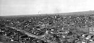 View
looking northeast from dance pavilion right South Lincoln St., 1922 or
1923. The photo must have been taken on a Sunday morning, as the streets
are empty. Even so the lack of cars is remarkable. Perhaps residents were
requested to move them? Perhaps streets were built first and the cars
came later? Most of Pocatello's downtown buildings had been constructed.
The Bannock Hotel is prominent in the middle of the view. The Union Pacific
smokestack and power plant are in full operation. The smokestack, visible
from all over town, still stands, unused, as a symbol of early days in
Pocatello and the Union Pacific Railroad. The Center Street viaduct is
in the middle of the view. Emerson School is in the lower right, with
the Portneuf River behind it. Note that buildings have been constructed
as close to the river as possible, with no allowance for the flood plain.
Indeed, surveyed lots of the original Pocatello townsite, carved from
the Fort Hall Indian Reservation in 1891, are strictly rectangular, parallel
to the railroad. The original plat does not include the Portneuf River
and many lots go across the river. As pointed out by Oscar Sonnenkalb,
such an urban design without any account for the natural terrain could
only have been done by the Federal Government from afar. Since the land
was removed from the Indian Reservation, the Federal Government, rather
than local business, determined how the city would be laid out. Sadly
for Pocatello, this mistake was a permanent one. The river is now hemmed
in not only by private property, but by a concrete flood control channel
built to protect that private property.
View
looking northeast from dance pavilion right South Lincoln St., 1922 or
1923. The photo must have been taken on a Sunday morning, as the streets
are empty. Even so the lack of cars is remarkable. Perhaps residents were
requested to move them? Perhaps streets were built first and the cars
came later? Most of Pocatello's downtown buildings had been constructed.
The Bannock Hotel is prominent in the middle of the view. The Union Pacific
smokestack and power plant are in full operation. The smokestack, visible
from all over town, still stands, unused, as a symbol of early days in
Pocatello and the Union Pacific Railroad. The Center Street viaduct is
in the middle of the view. Emerson School is in the lower right, with
the Portneuf River behind it. Note that buildings have been constructed
as close to the river as possible, with no allowance for the flood plain.
Indeed, surveyed lots of the original Pocatello townsite, carved from
the Fort Hall Indian Reservation in 1891, are strictly rectangular, parallel
to the railroad. The original plat does not include the Portneuf River
and many lots go across the river. As pointed out by Oscar Sonnenkalb,
such an urban design without any account for the natural terrain could
only have been done by the Federal Government from afar. Since the land
was removed from the Indian Reservation, the Federal Government, rather
than local business, determined how the city would be laid out. Sadly
for Pocatello, this mistake was a permanent one. The river is now hemmed
in not only by private property, but by a concrete flood control channel
built to protect that private property.