Page
141
|
Page
141
|
Originally, the Trail generally followed present-day Sheepskin Road west from the present town of Fort Hall and after dropping down to the Bottoms, approached the old fort from the north. A trace of this route can be seen upstream from the Fort. It crosses the slough east of the site of the fort to the open area next to the walls where until 1843, Pioneers were convinced by Fort personnel to leave their wagons and instead to proceed further by foot or horseback. The Hudson's Bay Company wished Pioneers to believe that the route to the west was too rough for wagons, thus discouraging exploration and settlement. According to Scadden, as time went by, the main route of the Trail shifted away from the Fort and after coming down onto the Bottoms more than a mile south of Sheepskin Road, it forded Clear Creek and ran parallel to Spring Creek to the Portneuf River, with a branch crossing Spring Creek to the Fort, about four miles away. This main trail eliminated several creek crossings and after the Clear Creek ford, which is only inches deep on a good base, there remained only the ford of the Portneuf River as the Pioneers moved to the west.
Persons wishing to go to the old Fort could cross Spring Creek at a major ford and reach the Fort, four miles distant, after fording Big Jim Creek. This route actually is shorter than the north route. Hudson's Bay Company abandoned Fort Hall in 1856, after reducing its use for several years, so there was no longer any reason to visit Fort Hall.
 |
 |
|
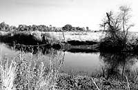
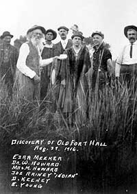
(left) View of the slough at Old Fort Hall from near the site of the old fort. The Oregon Trail branch probably crossed this slough here, (September, 1988). (right) Photo taken at Old Fort Hall, August 29, 1916. Ezra Meeker (old man on the left of the front row) was a pioneer who traveled the Oregon Trail in the 1850s and settled in Washington State. In 1916 he returned along the trail with a covered wagon and a team of oxen. Joe Rainey, an Indian and former U.S. Army Scout (left background) pointed out the site of the original fort, which had been lost in the marshes and meanders of the Fort Hall Bottoms. Dr. Minnie Howard and her husband Dr. W. Howard (behind and to her left) were champions of preservation of Oregon Trail and Pocatello history. They were both medical doctors and had four sons who became doctors. Howard Mountain, the volcanic hill northwest of the city, is named for the family. As this picture suggests, Dr. Minnie was not known for frivolity. Minnie Howard Collection, Idaho State University Library. |