Page
166
|
Page
166
|
The Hagerman Fossil Beds National Monument contains bones of Miocene horses, camels and other large animals that roamed the shores of Lake Idaho(a lake that occupied much of the Snake River Plain) between 7 and 3 million years ago.
 |
 |
 |
 |
||
|
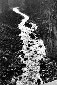
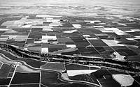
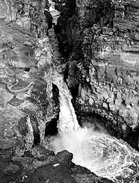
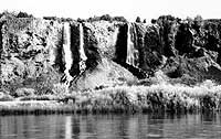
(left) Malad River (big Wood River) in Malad Gorge State Park.View looks downstream (southwest). The narrow canyon is geologically very young, cut in the last 2 million years, (March, 1993). (top center) View looking north at the Snake River Canyon below Murtaugh,west of Milner Dam. On the north side of the Snake River the road heads due north to beautiful downtown Hazelton. Greenwood is south of Hazelton and north of the Interstate Highway. The South Side Main Canal (Twin Falls Canal) parallels the river. The country in the distance that is not farmed is the scabland east of Eden. The farmland in the distance is near the Hunt relocation site, a World War II Japanese-American concentration camp,along the North Side Main Canal, (July, 1989). (bottom center) Waterfalls coming from part of the Thousand Springs on the north bank of the Snake River where the Snake River Plain Aquifer empties into the Snake River and feeds America's largest trout farming businesses, (May, 1986). (right) Waterfall below Interstate 84, Malad Gorge, (March, 1993). |
||
References
Greenwood, Annie Pike, 1934, reprinted 1988, We Sagebrush Folks: Moscow,Idaho, The University Press of Idaho, 489p.
Malde, H.E., 1987, Shoshone Falls, Idaho; A Pleistocene relic of the catastrophic Bonneville Flood: in Beus, S.S., editor, Rocky MountainSection of the Geological Society of America: Boulder, Colorado, GeologicalSociety of America Centennial Field Guide, Volume 2, p. 135-138.
Malde, H.E., and Powers, H.A., 1972, Geologic map of the Glenns Ferry Hagerman area, west-central Snake River Plain, Idaho: U.S. Geological SurveyMiscellaneous Geologic Investigations Map I-696, scale 1:48,000.
Stearns, H.T., Crandall, L., and Steward, W.G., 1938, Geology and ground-waterr esources of the Snake River Plain in southeastern Idaho: U.S. GeologicalSurvey Water-Supply Paper 774, 268 p.
Whitehead, R.L., 1986, Geohydrologic framework of the Snake River Plain,Idaho and eastern Oregon: U.S. Geological Survey Hydrologic InvestigationsAtlas HA-681, scale 1:1,000,000.
Whitehead, R.L., and Covington, H.R., 1987, Thousand Springs area near Hagerman, Idaho, in Beus, S.S., editor, Rocky Mountain Section ofthe Geological Society of America: Boulder, Colorado, Geological Society of America Centennial Field Guide, Volume 2, p.131-134.