Page
169
|
Page
169
|
|
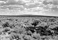
| Shield volcano north of Shoshone, (June, 1992). |
|
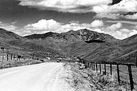
| Buttercup Mountain looking north up Willow Creek from Camas Prairie, northeast of Fairfield, (august, 1987). The mountain is underlain by Cretaceous rocks of the Idaho batholith and capped by Eocene Challis Volcanic Group. |
Geology
of the Wood River Area
The flat, alluvium-filled
Wood River Valley is the gateway to the Pioneer and Sawtooth Mountains of central
Idaho. The steep hills near the river are underlain by Paleozoic dark-colored
shale and limestone. To the west is the great Atlanta lobe of the Cretaceous
Idaho batholith. Most of the rich mineral deposits of the region are hosted
by black shales of the Devonian Milligen formation and formed during Cretaceous
magmatic activity and deformation. To the east is the geologically complex Pioneer
Mountains core complex, which contains, in the high peaks, complexly deformed
Early Proterozoic metamorphic rock intruded by Eocene plutons. Eocene volcanic
rocks of the Challis Volcanic Group cover large parts of the area west of Hailey
and Ketchum.
The
Goodale Cutoff
Originally used
by Oregon Trail emigrants, the Goodale Cutoff followed an Indian trail along
the present route of U.S. Highway 20 from Carey over the summit north of the
Queen's Crown and across the Camas Prairie. In the spring, near Fairfield and
Hill City, the marshy areas are purple with the blooms of camas plants. Indians
harvested the bulbs of this member of the lily family as a much valued food
source.
The
Camas War of 1878
The invasion of
Europeans into western Indian lands was overwhelming to the native populations.
Old ways of life could be followed no longer; tribal customs were subverted
by the white society; old hunting and gathering lands were being turned into
towns and farms. The reaction of many tribes was resignation. The technological
and monetary power of American society was all too obvious and pervasive.
In 1878, the Fort Hall Bannock Indians, under Chief Buffalo Horn, found that settlers in the Camas Prairie east of Fairfield had cut up the marshes into fields. Cattle and horses were pastured on land where the Indians had gathered camas roots for generations. Pigs were allowed to dig up the roots that had been one of the Indians' major food sources. This provocation, on top of a general atmosphere of tension, led to a series of attacks in the summer of 1878.
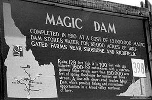 |
| Historical Marker south of Magic Dam on the Big Wood River south of Bellevue, (June, 1991). The dry years of 1987-1992 caused this reservoir to run out of water early and to deprive downstream farmers of irrigation water. The magic had ended. In 1990 and 1991 the water ran out in early July; in 1992 the water ran out in late May. After a wet year in 1993, when water was plentiful, 1994 was very dry and the canals were again empty. 1995 and 1996 were wet years. |
Chief Buffalo Horn and his followers moved southwest from Fort Hall, toward their ancestral lands in Nevada, raiding as they went. They destroyed property and killed settlers and freighters at King Hill, in the vicinity of Glenns Ferry, and in the Bruneau Valley. Several skirmishes with irregular white forces resulted in the death of Buffalo Horn and some of his followers.
New recruits were picked up along the way from malcontent and restless tribes. Some battles took place in the vicinity of the Owyhee River and the band, now numbering several hundred, headed for the John Day country. Regular army forces under General Howard, aided by friendly Umatilla Indians, caught up with the marauders and the leaders were slain, bringing an end to the outbreak. The warriors broke into small groups and gradually returned to their reservations. The Camas War was the final blow to Indian rebellion. It was followed generally by an attitude of sullen and sated subjugation that has lasted for nearly a hundred years.
Fairfield