Several methods may be applied to estimate the impact of ground water pumping or recharge on surface water resources. General application of these methods is discussed in the section on "Surface Water and Ground Water Interaction". The primary method used for the Snake River Plain aquifer has been numerical modeling. Numerical modeling allows us to use as much information about the system physical characteristics as we have available; however, our knowledge of the system is never complete.
Several models have been constructed of the Snake River Plain aquifer, or portions of the aquifer. The two most complete models were constructed by the University of Idaho for the Idaho Department of Water Resources (IDWR) and the U.S. Geological Survey (USGS). These two models have similar boundaries and employ the same computer code. They differ, however, in their purpose for construction and, consequently, their design. The USGS model was constructed largely as an investigative tool to explore concepts of the regional ground water flow and improve our scientific understanding of the system. The IDWR model was designed primarily as an aquifer planning and management tool. The IDWR model presents a more simplified concept of the aquifer in that it uses a single model layer. The single layer was used because it was felt that data were inadequate to develop the multi-layer approach used by the USGS. Nevertheless, extremely sophisticated concepts can be simulated with each model. Our development of models is limited by data availability and our understanding of the real system. A comparison of predictions from these two models is currently being explored as part of the Bureau of Reclamation's SR3 project. More information on these models can be found in Cosgrove and others (1999) and Garabedian (1992).
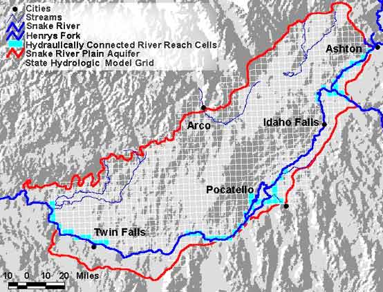
The model developed for the IDWR is the tool that has been, and probably will continue to be, used for evaluating ground water and surface water relationships. Click here for a view of the IDWR State model grid and boundaries. The model was used to perform the Upper Snake River Basin Study (IDWR, 1997) and was used to develop response functions for the river and aquifer (Johnson and Cosgrove, 1999, to be supplied).
The models of the Snake River Plain aquifer described above have been used for many years and presently are accepted to represent the effects that consumptive ground water pumping and managed recharge have on ground water storage and on interactions between the river and the aquifer. However, it is important to recognize that these models are not precise. Although our models will never be perfect, they can always be improved. For example, more ground water-level measurements are needed near the Snake River to better understand and represent the interconnection between the river and the aquifer.