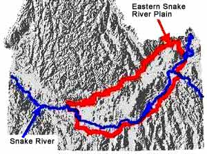
 The
eastern Snake River Plain extends as a two hundred mile long arc, about 60 miles
in width, across southeast Idaho. This plain was formed by the deposition
of basaltic lava extruded from numerous vents across the plain. Wind and
water deposited sediments overlie the basalt in most areas and are also found
interbedded with basalt flows in the subsurface. A more detailed geologic
description can be found in the sections on Hydrogeology
and Origin of the Snake River Plain.
The
eastern Snake River Plain extends as a two hundred mile long arc, about 60 miles
in width, across southeast Idaho. This plain was formed by the deposition
of basaltic lava extruded from numerous vents across the plain. Wind and
water deposited sediments overlie the basalt in most areas and are also found
interbedded with basalt flows in the subsurface. A more detailed geologic
description can be found in the sections on Hydrogeology
and Origin of the Snake River Plain.
Precipitation ranges from
about 8 inches/year in the lower elevations in the west to about 14 inches/year
in the higher elevations in the northeast. The majority of the water supply
originates in mountains on the north and east sides of the basin, including
the southern portion of Yellowstone National Park. Within the boundaries
of the Snake River Plain, rainfall is insufficient to support commercial levels
of agriculture without irrigation that requires substantial diversions from
surface and ground-water systems. The Snake River flows along the southern
margin of the plain, fed by tributaries flowing out of the mountains on the
south and east side of the plain. A few tributaries from the northern
valleys flow into the Snake River, but many disappear through seepage into the
permeable Snake River Plain basalts.
Information supplied
by Idaho Water Resource Research Institute, University of Idaho December 1998
Authors: Dr. Gary Johnson, Donna Cosgrove, and Mark Lovell.
Graphics: Sherry Laney and Mark Lovell of Idaho Water Resources Research Institute.
All State of Idaho images and graphics created with GIS files obtained through
Idaho Department of Water Resources Public Domain GIS unless otherwise noted.
Source
Information