Western Snake
River Plain- Treasure Valley Ground Water (p2)
Ground Water
Levels
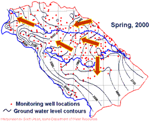
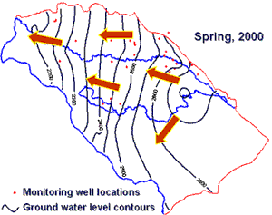
Ground water levels have been measured on a regular basis as a part of the Treasure
Valley Hydrologic Project. Over 350 Treasure Valley wells were measured six times
in mass measurements. A mass measurement is the measurement of a large number
of wells in a short time (in this case, usually within a one-week period). Mass
measurements were conducted in spring and fall of 1996, 1998, and 2000 by the
U.S. Geological Survey (http://id.water.usgs.gov/). A mass measurement provides
ground water level information at one period in time, which is used to determine
a potentiometric surface (in an unconfined aquifer the potentiometric surface
is the water table). The potentiometric surface is used to determine ground water
flow directions.
|
Shallow
Aquifer Water Levels |
Shallow
Aquifer Water Levels |
|
|
| Interpolation by Scot Urban,
IDWR |
|
In addition, water levels in about 70 wells have been measured on a monthly
basis. Hydrographs, drawn from monthly water level data, are a graphic representation
of water level data over time for one location.
Ground
Water Level Changes
Seasonal changes in ground water levels can range from few to about 10 feet.
These seasonal variations depend on the amount and timing of local recharge
and pumping.
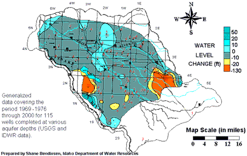
Ground water levels in most parts of the Treasure Valley have remained relatively
constant. A water level change map for the Treasure Valley compares water levels
from the period 1969-1976 with water levels in the year 2000.
| Water
Level Changes (1969/1976-2000) |
 |
 BACK
NEXT
Original content compiled
by Christian Petrich, Margie Wilkins, Tondee Clark, and Tony Morse.
Images by Scot Urban and Shane Bendixsen for Idaho Department of Water Resources
Adaptation for the Digital Atlas of Idaho by Ean Harker- design/html, Kyle Raverty-
content, 11-2002.
Information supplied by the Idaho Department of Water Resources; 1301 North
Orchard Street Boise, Idaho 83706 (208) 327-7900.


