|
Page
130
|
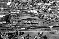
1) Union Pacific yard and shop facilities from Sherman to Lander Streets (left to right). The white building east of Harrison Ave. is Edd Bailey Hall, a retired railroad workers' gathering place named for a former President of the railroad. The site of the Ramsey Transfer was directly south of Edd Bailey Hall. The parking lots west of the railroad define the original right of way. "Company Row" was located east of North Harrison Ave., South of Edd Bailey Hall. The original steam engine turntable remains in the middle of the railroad facilities, but the roundhouse, the steam engines and the coal smoke are gone. A connector to the Union Pacific Montana mainline runs north in front of the white grain elevator.
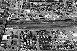
The Pacific Hotel was located on Center Street, between the railroad tracks, from 1883 to 1915. For the first 30 years of their city, Pocatellans crossed the railroad at grade in front of the Pacific Hotel, at risk of life and limb. In 1911 a viaduct was built over the tracks and the south half of the Pacific Hotel was demolished. The viaduct was replaced by the present underpass in 1934.
On the east side of the tracks is "Newtown," traditionally the "rough" side of town. The Center 151 Building on Third Ave. between Center and Clark Streets and the new Federal Building and U.S. Court House on Fourth Ave. between Bonneville and Whitman, were built in the mid-20th century, part of a process of "gentrification." They supplanted the ethnic neighborhoods that had existed on the east side of the tracks
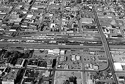 3)
Center to Benton Streets, in the center, the Union Pacific Railway Station
is at the end of West Bonneville. The original railroad right-of-way extended
west to Harrison Avenue, directly in front of the station. The offices of
the railroad, in 1996, share this grand building, built in 1915, with facilities
of Amtrak, which has operated the national rail passenger
network since 1971.
3)
Center to Benton Streets, in the center, the Union Pacific Railway Station
is at the end of West Bonneville. The original railroad right-of-way extended
west to Harrison Avenue, directly in front of the station. The offices of
the railroad, in 1996, share this grand building, built in 1915, with facilities
of Amtrak, which has operated the national rail passenger
network since 1971.The Pacific Greyhound Building, built on the original right-of-way by the Union Pacific during World War II, is in front of and south of the train station. It replaced a bus station in what is now Station Square (the Fargo building) at the corner of West Lewis and South Main. The Yellowstone Hotel stands on the northeast corner of West Bonneville and South Main.
The Idaho Division dispatchers' office for the railroad was located in the park area immediately north of the train station. In 1989, the entire Union Pacific and Missouri Pacific dispatching system was centralized at Omaha, Nebraska. Dispatchers are but one of several categories of railroad jobs that Pocatello has lost to centralization.
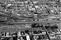
Note the triangular building left (north) of the off ramp to the Benton Street bridge. This building (the Elk's Club) conforms to the right-of-way for a water pipeline granted to Oregon Short Line in the Act of 1888. Part of the network of parks of the Portneuf Greenway will be built on this right-of-way.
East of the tracks, between Lewis and Bonneville Streets and First and Second Avenues, was the location of the walled city (red light district). This was also the ethnic side of town, the only places where Black, Chinese, and European immigrant railroad workers could rent a room in the early 20th century. The north end of the Warehouse district occupies the area immediately east of the tracks from Bonneville Street to the south. Note several buildings built with a triangular shape because of railroad sidings, now long gone. A small rectangular building with a black roof north of Lewis Street is the Shaw Building, originally built to house the telephone office. The former Pocatello City Police Station (hidden by trees) is across Lewis Street from the Shaw Building.